

Your Neighborhood Doesn't Exist (According to the Data)
The critical failure of community measurement, how to fix it, and why I need your help to do it.

The path of social renewal runs through our local communities. They are the seedbeds of democracy, with a unique power to build bridges across identities and foster connection, belonging, and civic participation. “The Neighborhood is the Unit of Change.”
Folks are catching on. From the bottom-up to the top-down, there is a surge of energy around reinvigorating our communities of place. For example, the Chronicle of Philanthropy estimated that there was $2.5 billion invested in place-based efforts in 2023, along with tens of millions of new investments in 2025. Wow!
Measurement is the compass of social renewal. For example, understanding that 41% of Americans often feel lonely, or that 74% of Americans want to work together to improve their community, provides motivation and benchmarks to spur community-building work.
But there’s a sticky problem: how do you define “community”? Community is an extremely ambiguous and, sadly, increasingly meaningless term. A community in today’s parlance, can mean all sorts of things. For example, a Reddit community, a disability community, or a community of care.
But even when focusing on communities of place, the definition is still wide open. For example, in a recent Substack post, I highlighted how many interpretations there could be for a research question about “local community,” such as a few blocks, a neighborhood, or an entire city.
How do we gauge or foster our emotional connection and sense of belonging with the places where we live, without clearly defining what the heck we’re talking about?
The problem isn’t abstract.
Here’s an example: the Social Trust Map, assembled by the great folks at the “Weave: Social Fabric Project” at the Aspen Institute. The Map takes available data about social trust and creates an interactive map of the entire country. You can browse it to see where your “community” stands with its social trust metrics. It’s wonderful, well-intended work.
Here’s what it looks like for my neighborhood in Southeast Seattle.
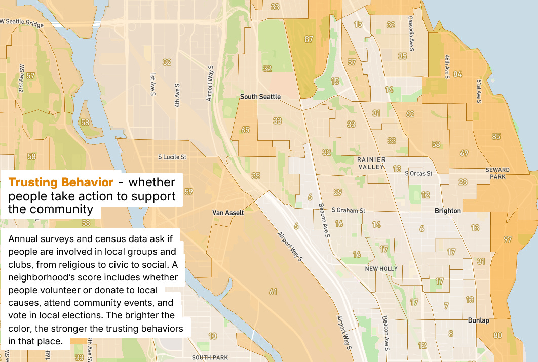
But let’s say I want to put this map to use. Perhaps I’m a community activist and I’m curious to know the existing levels of social trust in my neighborhood. Or perhaps I’m a local government looking to invest in trust-generating places, and I need some guidance on which communities are most in need.
So I turn to this Social Trust map.
And this map is basically useless.
Why? Because it’s mapped out in census blocks — arbitrary geographic units determined by the US Census Bureau.
Census blocks have NOTHING TO DO WITH HOW WE CONCEIVE OF OUR COMMUNITIES.
Do you know which census block you live in? Probably not.
But if someone asked where you live, I’ve guessing you have some conception of the *neighborhood* you live in.
And it’s likely that most of your local institutions, organizations, and relationships are built around that conception of your neighborhood.
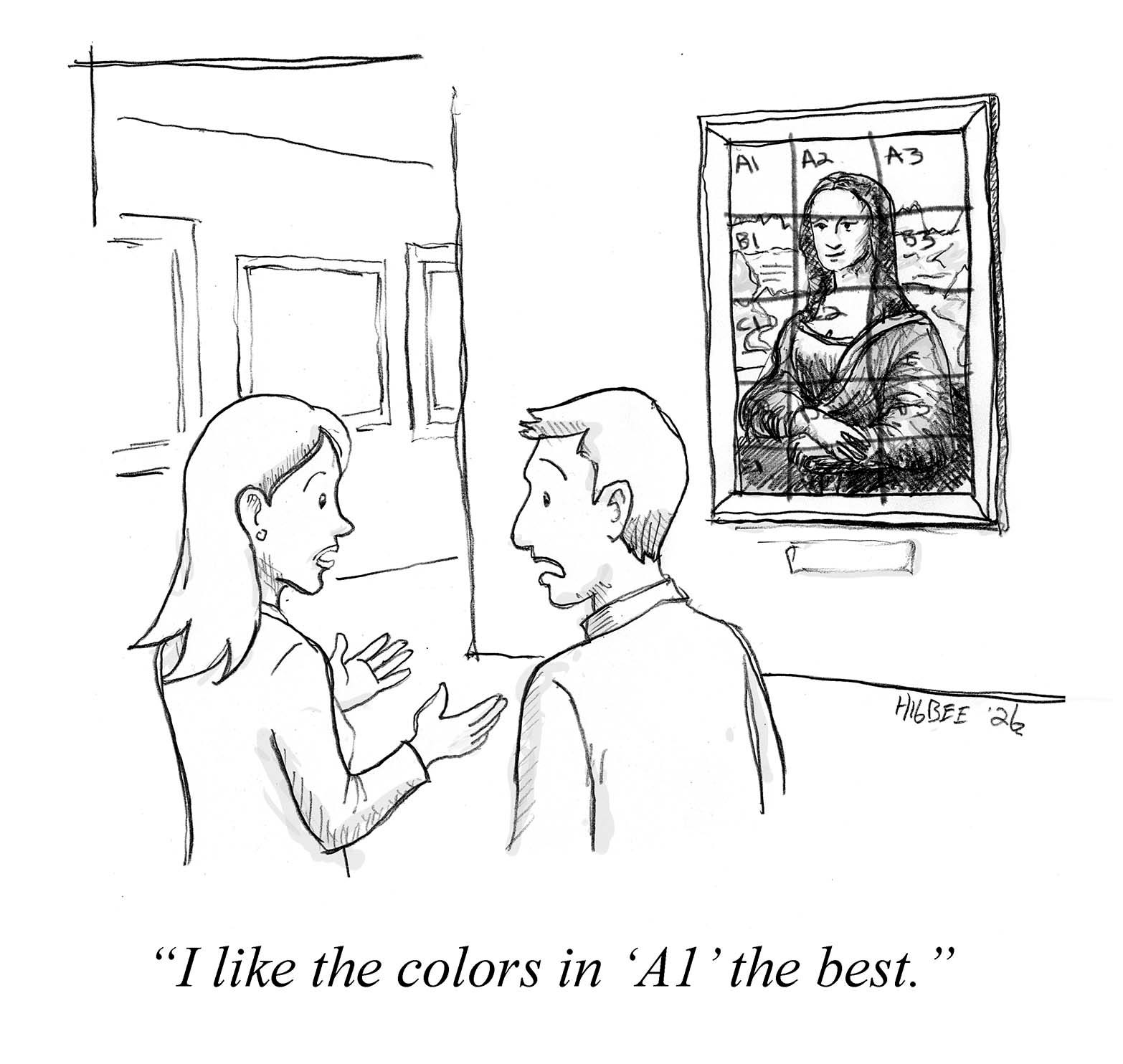
It’s like trying to understand a painting by analyzing it one square inch at a time using grid lines. You’d have data on every square — color, texture, brushstroke — but no way to see the faces or figures. The unit of analysis has nothing to do with the unit of meaning.
It’s like trying to understand a painting by analyzing it one square inch at a time using grid lines… The unit of analysis has nothing to do with the unit of meaning.
To illustrate the point, here’s a quick sketch of the constellation of neighborhoods in my corner of Seattle, drawn over that same snapshot from the Social Trust Map. The outlines represents my primary neighborhood of Columbia City, and the stars represent centers for some adjacent neighborhoods.
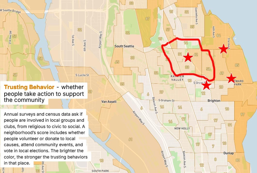
You can see that neighborhoods split or span multiple census blocks. It’s just about impossible to cobble together the right census blocks into something that meaningfully resembles a neighborhood.
It’s unusual to have this level of data at as small a scale as the census block level. Many of these types of maps are at the zip-code or county level, which is WAY too big a geographic scale to be useful. For example, the Social Capital Atlas, The Civic Opportunity Map, The Third Place Index, or the Civic Information Index.
I don’t mean to diminish all the smart, talented people doing this work — their values and intentions are in exactly the right place.
But, really, does anyone actually use this data? How much money and time was spent in making this stuff?
Wait, but don’t neighborhood boundaries already exist somewhere?
So you might ask, don’t these boundaries exist somewhere? Can’t we just use them?
I’ve spent some time researching this question. What I’ve found is that yes, there are some existing neighborhood boundaries, but it’s quite the hodgepodge and their provenance is murky.
Some municipal agencies publish GIS (Geographic Information System) boundaries of their neighborhood. Online mapping services, like Google or Redfin or NextDoor, have their own neighborhood definitions. None of them are in agreement or have any claim to accuracy.
Here’s the thing: neighborhoods are cultural constructs. They are defined by the people who live there. They are fluid, fuzzy, and contested. And they change over time.
Neighborhoods are cultural constructs. They are defined by the people who live there. They are fluid, fuzzy, and contested. And they change over time.
All this makes pinning them down, perhaps, a Sisyphean task.
But there might be a way.
It begins by asking neighbors themselves to define the place where they live.
Enter Stage Left: the New York Times Neighborhood Mapping Project
In 2023, The New York Times (NYT) published an extraordinary map of New York City’s neighborhoods. This map was crowdsourced from NYC residents through a simple online interface. The interface first asked, “What do you call the place where you live?” and then asked respondents to draw a line on a map around how they define that place.
The results are breathtaking and fascinating. Take a look at it here.
All sorts of insights arise from this information. You can see how neighborhood edges can be fuzzy or sharp. Or how they change over time. And how they don’t line up with other official neighborhood boundaries. The NYT breaks down such insights in their accompanying article.
So here’s the crazy idea: Could we create similar crowdsourced maps for all our towns and cities? And could we then extract some sort of neighborhood boundaries, however fuzzy, to use in our measurement tools and community building work?
Such neighborhood boundaries could replace zip codes or census blocks as units of measurement. They would be living, relevant units of measurement that could actually be used in measuring the metrics of place-based community life. We would be looking at each painting within its frame, not arbitrary grids laid over the top.
I got excited enough about this idea to find out whether it was possible. So I talked to the folks at the NYT about how they did it, and it turns out it’s not that complicated.
Launching the Prototype
I decided to build a prototype based on the NYT interface for my own neighborhood in Southest Seattle, Columbia City. With the help of AI, in a few weeks I built a serviceable website, and then placed a couple of posts on our neighborhood Facebook group. Within a few days I had over 300 responses. Not bad.
I processed the responses and generated a map for Columbia City and its adjacent neighborhoods that looks like this:
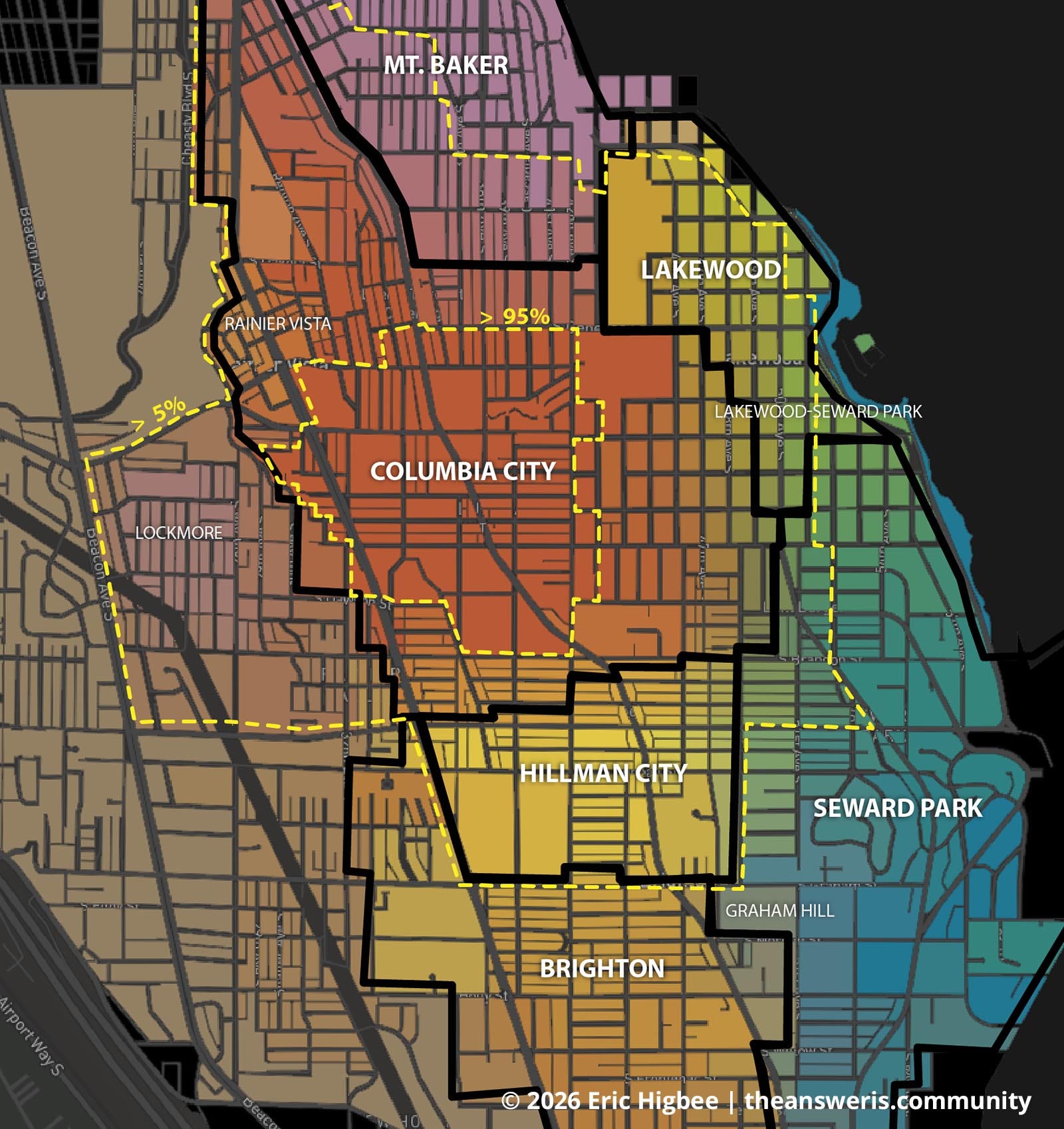
On this map you are seeing three boundaries. The smallest yellow-dashed boundary is the strictest conception of the neighborhood that just about everyone (95%) agrees is “Columbia City.” The largest yellow-dashed outermost boundary is its most generous conception of the neighborhood, where a smattering of folks (5% or more) thought of it that large. The dark line defining the different neighborhoods simply delineates the most “votes” for a neighborhood name within a block, although this boundary is subject to a lot of representative sampling error.
Look at that! We now have a working boundary for the neighborhood that is much more useful than census blocks or zip codes.
From Data to Action
As I was constructing this interface, I had an epiphany: seeing as how people were already contemplating their neighborhoods, it made sense to solicit their opinions on how they felt about them. The moment seemed especially opportune. Measuring things like place-attachment and place-identity — which I argued in my last Substack post are critical and often omitted measurement criteria — is a heck of a lot easier when folks just spent some mental energy defining the “place” where they live.
So I tacked on an optional 20-question survey based on all of my research into measuring community. About two-thirds of the people who drew their neighborhood boundaries also completed the survey.
The results from this extra survey were also remarkable. I was able to see across six different neighborhood differences in neighborhood-level social connection, identity, and power. Here’s a little snippet comparing a subset of the questions in two of the neighborhoods:
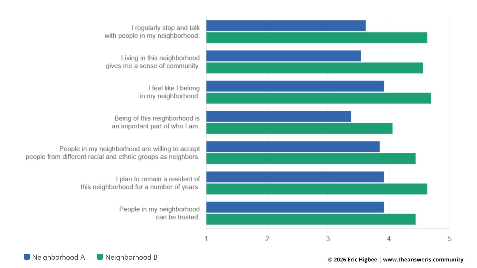
The data from this survey is useful in its own right, but what makes it really powerful is its connection to the users’ conceptions of their neighborhood. When folks are talking about their relationship to their local community, we know what local community they are talking about!
*Now* we can start to ask some really useful questions. Not just with this data, but with any type of community measurement data.
Why does Neighborhood ‘A’ have lower levels of connection, identity, or trust, compared to Neighborhood ‘B’? What local organizations, places, or institutions within the neighborhood are contributing to or detracting from these things? If we want to support community building, where can we best invest? Five years later, did our investments change anything?
Folks, this is how measurement is linked to action. If we want to scale up our place-based community work as a path towards social renewal, we need the right geo-spatial frame. And that frame needs to be defined by the people who live in those communities.
It all begins by asking, “What do you call the place where you live?”
Toward Impact and Why I Need Your Help
This stuff seems so exciting and critical to me. Don’t you think so? It’s hard to imagine that we are going to make progress in social and civic renewal without this missing geo-spatial component. How can folks be throwing billions of dollars and countless hours of energy towards community building while lacking a basic unit of measurement to understand or evaluate the work? How can we talk about strengthening our local communities, without at least some spatial conception of what they are?
This need seems so obvious. In fact, I’ve been told that this is essentially an open-secret amongst those who measure social connection.
Certainly, someone would want to support the creation of community-defined neighborhood boundaries?
I put together a proposal for implementing this idea for the 20 largest U.S. cities. I figure it’ll take about $300k. Or for just one city, about $125k. (Once you build the interface, it’s cheaper to expand to other cities). That might seem like a lot, but given the amount of money folks are investing in community work these days (see the aforementioned $2.5 billion), one would think it would be worth shoring up this critical piece of measurement infrastructure.
Yes, there are some unanswered questions about who would manage the work and host the data, but these are all surmountable challenges, especially once the funding is secured. I got a lot of ideas.
Over the past few months, I’ve been reaching out to anyone who I think might be interested. Sending emails, making cold calls, Zoom conversations, working my networks, research.
I can’t get anyone to bite.
Once upon a time, I was an Executive Director of a non-profit, so I know how this stuff works: Ya gotta know people. Or, ya gotta know people who know people.
I don’t know the right people.
So dear, readership — all 1500 of you — can you help?
First, give me some perspective: Is this thing as important and exciting as I think it is? Or am I just spinning in my own GIS mapping- and community-geek bubble?
Please let me know your thoughts in the comments. And/or after this post goes out, I’m going to launch a Substack Chat Thread. You should get an email from Substack about it. Please hop on there and let me know what you think.
Second, can you help me with connections, funding, or logistics? Who should I talk to? Can you make an introduction?
Or maybe you want to collaborate and help me get this thing off the ground? Perhaps a working group to move this idea forward?
Please reach out to me with a message.
***
The path forward starts with a simple question: “What do you call the place where you live?”
That question is the seed of everything I’ve described here. It puts neighbors back in the driver’s seat. It says: you define this place. You draw the lines. These are our living neighborhoods. And once we have those lines — messy and contested as they may be — we can start asking the questions that actually matter. What’s working in this neighborhood? What’s broken? Did that investment five years ago actually move the needle?
Right now, we’re pouring billions into place-based community work, and we’re doing it half-blind. We have maps that don’t match how people live. We have data carved up by arbitrary bureaucratic lines. We’re trying to read the painting through someone else’s grid. Let’s kick census blocks and zip codes to the curb, and use instead something that actually matters.
This is a fixable problem. We have the technology, the precedent, and a working prototype. What we need is the will — and, honestly, not that much money — to do it at scale.
Social renewal begins in our neighborhoods. It’s time our measurements did too.
~Eric
Become a paid subscriber, and get a super cool T-shirt!
Do you like what your reading? The Answer is Community continues to fill a unique niche amidst a surging interest in social and civic renewal. It is inspiring minds and changing practice for those engaging with communities. Your support will help me expand my audience, and let me prioritize my writing amongst a host of competing demands for my time.
I’m offering a free T-shirt to anyone who steps up to become a paid subscriber, or gives a subscription as a gift. Featuring my hand drawn “Hello, My Name Is” graphic. It’s your new essential piece of community engagement gear!
Check out the offer, and the T-shirt, in my previous post. Or just go ahead and subscribe! Thank you for your support!
Hey, Eric! bcWORKSHOP did a similar neighborhood mapping project in Dallas about a decade ago (https://www.bcworkshop.org/pop-city-map). I'm working on belonging and community measurement work within a neighborhood in southwest Houston and would be interested in helping! I've also been beating my head against the administrative boundaries constraining our ability to meet needs and advance people's capabilities in their neighborhoods. I'm just wrapping up some graduate work on impact assessment and measuring long-term outcomes throughout infrastructure development life-cycles.
Insightful article Eric. There's great value in asking these more meaningful questions, like "What do you call the place where you live?" In my experience, community building efforts focused on neighborhood wide initiatives are still to broad and wide of a scale to create positive impacts in most residents' lives. If you ask me, my answer would be I live on the 300 block of MYSTREET. I believe that hundred level block of any given street is a more practical and effective description of nearby neighbors' shared attachment to a place. Within an average neighborhood their could be thousands, if not tens of thousands of people that live out vastly different experiences based on where within those neighborhoods they do live.
More specifically, I would point to the nearest corner intersection/cross-street as a more realistic geographic description of where I live. Practically speaking, I would hypothesize that there's about a 200 foot radius from most traditional single/multi-family residential home addresses that is really the place where we live. That includes all of the adjacent properties 360 degrees around our own home, and probably an additional ring of the next property or even two. This encompasses the line of sight from most front and back doors. Try visualizing looking out your 2nd floor windows or down the adjacent row of front porches/stoops. In the neighboring space, there's an exercise called the 8-Front Door Challenge that encourages residents to test themselves to see how many people they know that live in the nearest 8 front doors to theirs, try it. It's a great litmus test and starting point for where you are today, and an invitation to learn names going forward.
This is where we actually live most days. But more importantly, these are the people that we're most likely to regularly interact, cross-paths with, and see coming and going during most of our everyday lives. These hyper-local subsets (pods, clusters) are where the real magic of community building happens. And it's the strength of the relationships with those geographically closest to us that can and will most often make the biggest difference.
For most neighbors, the vast majority of us CAN (we have both the capacity/bandwidth and willingness) be one of the best real-world, social, support and safety networks for each other. If/when we take the time to do any/some of the things that connected neighbors do, including: introduce ourselves, learn/remember names, exchange contact information to open up a line of communication, extend invitations, spend more time outside and/or in shared/common spaces, ask for a helping hand, and be curiously inquisitive. When we do this, we're going to discover we have so much more in common with the folks that are actually, physically right next door. And within any given block I'd bet there's a critical mass of people
that would love to join a card night, chess club, walking group, book club, parent group, dog/cat group, video game group, etc... the list could go on almost infinitely.
When we start down this neighboring path, we're going to surely strengthen those nearby relationships and slowly build trust. And that's when the positive ripples that I often refer to as "neighbor magic" start to compound. There's a beauty and a simplicity on this scale as their are no real transportation or time costs to walk across the street, down the block or around the corner. That convenience can greatly increases the value of those nearby connections. When residents have established and started to build on those foundational connections, those households are happier, healthier, safer, more resilient, wealthier and the list goes on.
The US Chamber of Connection, the University of Missouri and others have done a fantastic job of outlining many of the positive impacts of strengthening this hyperlocal social fabric. Trusted, known neighbors are going to look out for your best interests whether you're asleep, on vacation, at work, or just not yet aware of a situation. They're going to be unofficial stewards of your property, caretaker's of your kids when they're down the block, and be the unsung heroes to chase down and return your pets when they run off after a wild animal. Neighbors are the best go-to problem-solvers and fix-it guys/gals to secure an important valuable package on your front porch, or to water your beautiful flowers during a drought when you're out of town. They're the life-savers when your mower dies before you host a big event, and they happily let you borrow theirs to finish the job. They are overjoyed when you can borrow an underutilized asset, like a second crockpot, or a wheelbarrow or a dolly. Every house on the block doesn't need their own power washer or snowblower or extension ladder. In fact, simple acts of sharing/borrowing are the basic exercises that strengthen those neighborly muscles.
When my wife bakes a coffee cake, we usually drop off some extra slices to our closest neighbors as they've done the same so many times before. When new neighbors move to the block, I pop-in some easy-bake, pre-made cookie dough (if I haven't already eaten most of the squares) and deliver a hand-written welcome note with my name and number. My daily walk around the block with our pup is honestly my favorite ritual as it so often leads to countless unexpected, heart-warming and encouraging interactions with nearby neighbors.
We should and could be investing in more of the community organizing initiatives that brings people together around the US Chamber of Connection's Six Points of Connection, such as Communities of Play, Communities of Service, Third Places, and Neighbor Connections. This is the ounce of prevention that is worth well more than a pound of cure. More of our cities' neighborhoods would be better off long-term if/when they focused on sparking stronger connections between nearby neighbors.
Ok, holy moses, end rant. Where's the Tylenol? Let's chat more.